This project was my final engineering project, done in a team of 4 people, with guidance from the City of Windsor. This project involved the design of stormwater management facilities for a proposed urban residential infill development. The project involved two main aspects – sewer network simulations for different design storms, and the design of stormwater infrastructure, such as low-impact water storage and storm sewers. The goal of the project was to design stormwater infrastructure so the resulting development would not impact flooding downstream of the site.
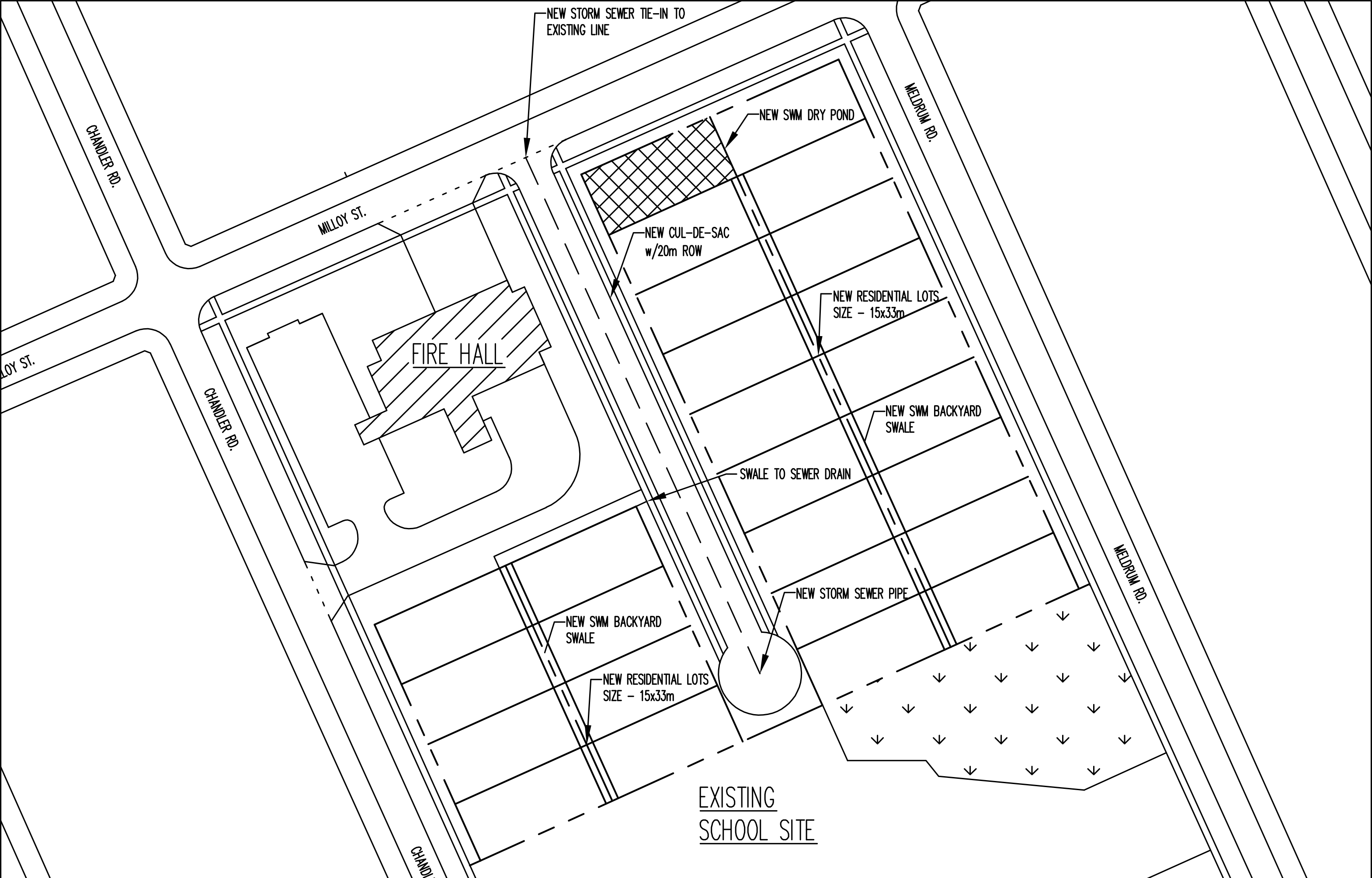
The new sewer and low-impact infrastructure was designed using the Rational Method. The foundation of design included the limits on diameter (min 300mm), maximum pipe length (120m), and maximum flow velocity (3m/s). The Rational Method was used to calculate the peak flows for the sewer and determine the recommended diameter. The resulting design included 3 conduits ranging from 375-525mm (1 of which being a tie-in) and 2 new manholes. The low-impact storage method to store excess runoff was chosen to be a dry pond system – a pond filled with a coarse stone and covered up with grass, appearing as a depression in the ground. The pond would retain water in the voids, allowing the water to drain out via a conduit to the storm sewer at a managed rate. Water would be directed toward the pond using a swale running along the backyards of the residential properties. The dry pond was designed to control a 100-year storm, resulting in approximately 275 cubic metres of stormwater for the site that could not be stored by the roads. The final design for the pond ended up being a 30x11m rectangular hole with a trapezoidal section, sitting at the lowest point in the neighbourhood.
The simulation aspect of the project was done to show the design work in practice under the design conditions. The sewershed that was influenced by the development of this site was identified using an online city resource. The resulting sewershed catchment area was approximately 2 square kilometres with 2 main outfall points into the Detroit River, and was a mix of old (>80 years old) and new pipes. Next, runoff coefficients (percentage of rainwater that gets absorbed by the ground) were determined for different classifications of properties – such as detached residential, greenfield, and commercial/industrial. The identified sewershed and catchment areas were modelled in PCSWMM, a Storm Water Management Model software package. The resultant model was then simulated in three scenarios, with four different design storm hyetographs each (5-year storm, 100-year storm, and 2 local design storms from 2016 and 2017 that caused flooding in Windsor). The scenarios simulated were pre-development (current conditions of site), post-development (development neighbourhood with no low-impact solution), and post-management (development of neighbourhood with dry pond). The simulation results showed an increase in flooded manholes and outfall flows from pre to post-development, with a decrease below pre-development levels in the post-management scenario, showing that the design was effective at managing the effects of downstream flooding.
The final cost estimate for this project came in at approximately $800,000 CAD.
The main resources used in this project included the City of Windsor Development Manual, Urban Storm Drainage Management, the 1949 Soil Survey of Essex County, City of Windsor MappMyCity, and the ERCA Stormwater Management Standards Guide.